
Frequently asked questions
WaterAlert is a system offered by the United States Geological Survey (USGS) that allows you to receive updates about changing water conditions at select locations. You create alert subscriptions for changes in water conditions at a monitoring location that you care about. When those conditions change in way that meets your subscription thresholds, you will receive an alert notification through email or text.
Here's some information to get you started.
-
Find a monitoring location.
-
Tell WaterAlert which monitoring location.
Use National Water Dashboard to connect with WaterAlert.
-
Select a water condition in which you have an interest.
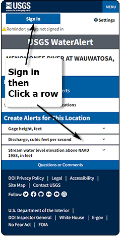
In WaterAlert, sign in then click one of the water conditions rows - which water conditions are available is dependent on the sensors at the selected monitoring location.
-
Set your thresholds.
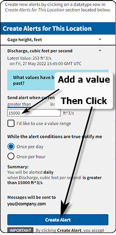
Enter a threshold value, click Create alert and you're done! WaterAlert will send you a notification when water conditions match your thresholds.
For specifc details about the functioning of WaterAlert, checkout out the Everything you ever wanted to know about WaterAlert section of the User Guide.
No, WaterAlert is a service provided by the USGS allowing you easy access to information about changing water conditions. You can receive WaterAlert notifications through email or text messages. If you use text messages, your service provider may charge you a fee depending on your service agreement with that provider.
Alerts have an expiration date set for one year after the latest edit or renewal of the alert. You will receive an email warning you of the upcoming expiration of your alert 2 weeks before it expires. Click the "Renew" button for the alert to update the expiration date and keep receiving the alert. You can review the status and expiration of all your alerts in your My Alerts list.
No, WaterAlert is an informational service only. Because of limitations within the system, alert notifications might not reach you in a timely manner during an emergency.
Please see the WaterAlert service statement for more information.
Maybe, WaterAlert depends on data from monitoring locations. If there is a monitoring location on stream ‘X’ that has sensors that provide data compatible with WaterAlert, you can get alert notifications for that location.
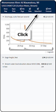
A monitoring location is a physical location where the USGS (or another agency) has located a set of sensors capable of measuring various water conditions. The process of creating alert subscriptions in WaterAlert depends on you telling the WaterAlert application in which monitoring location you are interested. With that information, WaterAlert can show you what types of sensors are reporting data at that monitoring location.
Individual monitoring locations are identified in the WaterAlert system by series of numbers, such as 01646500. In an internet browser, you can see the identifier for monitoring location WaterAlert is currently using by looking at the URL. The identifier is the number after the ‘#siteNumber=’, for example https://accounts.waterdata.usgs.gov/wateralert/my-alerts/#siteNumber=01646500.
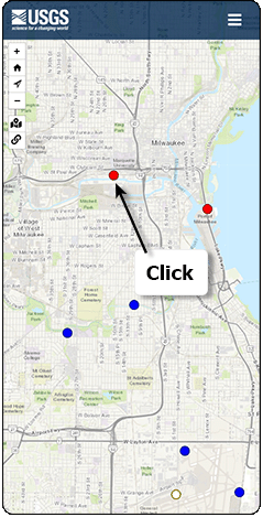
To start creating alert subscriptions, you will need to tell WaterAlert in which monitoring location you have interest. The USGS offers several web applications that allow you to find monitoring locations of interest. Currently, the recommended option is the National Water Dashboard.
Clicking on a map pin in the National Water Dashboard will show more details about that monitoring location. If the location has ‘current conditions’ data, you should see a link to WaterAlert. The link is labeled ‘WaterAlert’. Using this link will tell WaterAlert which monitoring location you would like to use, and will take you to a WaterAlert page customized for that monitoring location.
Alternatively, you can copy the monitoring location identifier for the location of interest and add that to the URL for WaterAlert as described in What is a monitoring location.
How to use WaterAlert
Everything you ever wanted to know about WaterAlert and maybe a little more . . .
What is WaterAlert?
WaterAlert is a system offered by the United States Geological Survey (USGS) that allows you to receive updates about changing water conditions at select locations. You create alert subscriptions for changes in water conditions at a monitoring location that you care about. When those conditions change in way that meets your subscription thresholds, you will receive an alert notification through email or text.
Back to indexDisclaimers about use of WaterAlert for safety decisions (and any other important notes)
While the USGS strives to prevent service interruptions, there are times when equipment malfunctions and fails to provide data for WaterAlert to use to send out alert notifications when appropriate. Users are cautioned to consider the limitations of the service before using it for decisions concerning personal or public safety or the conduct of business that involves monetary or operational consequences.
Please read WaterAlert service agreement and Current and historical instantaneous data availability statement for more information.
Back to indexHow & when do sensors capture data?
The sensors that monitor conditions at a location record data on timed basis, often on 15-minute intervals. It is important to note that not all sensors record data that often. Additionally, the intended interval is not always the interval on which the data is recorded, various mechanical and other issues can prevent the monitoring system from recording data at the expected time.
Recorded data is transmitted to a data storage facility. The timing of data transmission from the sensor at a monitoring location to the data storage facility can vary and several data recordings may be sent in a single transmission interval. Therefore, even though the data may have been recorded every fifteen minutes, WaterAlert will not have access to that data until it is transmitted.
Back to indexThe anatomy of an alert subscription
In WaterAlert you create alert subscriptions for water data values at a monitoring location. When water conditions at that location match your subscription’s settings, you receive an alert notification.
A sample alert subscription looks like:
You will be alerted daily when Discharge, cubic feet per second is greater than 4 ft^3/s
Breaking this down into parts we see . . .
-
The delivery interval: You will be alerted daily
-
The data type: Discharge, cubic feet per second
-
The threshold: is greater than 4 ft^3/s
Let’s look at the parts in reverse order.
Threshold: When water conditions meet your alert subscription threshold, you will get an alert. Thresholds are set using numerical values and can be decimals and even negative. A threshold will always have at least one compare operator (either less than or greater than). Greater than is by far the most used operator and is the default choice. If you wish to use less than, you can click that option in the user interface.
Thresholds can also cover a range of values such as greater than one but less than two. Using the range option in conjunction with the greater than and less than options allow you to create inner and outer ranges.
To help you understand the threshold setting you have set, WaterAlert always provides a summary statement of your threshold statement. Additionally, for sensors that have reported operational limits, you will see a range indicator visualization the clearly shows what values will meet your threshold settings.
Data type: Monitoring locations may have many sensors that measure data on water conditions. The data type is the descriptive name of data collected by that sensor. Some monitoring locations will only have one or two data types. Other locations might have ten or more.
Delivery interval – daily/hourly: The delivery interval is how often after you received the initial notification you would like to receive reminder notifications. WaterAlert will attempt to notify you as soon as possible that your threshold conditions have been met. After that initial notification, WaterAlert will check the data again either once per hour or one per day, and if your threshold conditions are still true you will receive another alert notification.
Back to indexHints for creating alert subscriptions
- Be aware that sampling intervals can vary.
- Be aware that reporting intervals can vary - just because the sensor takes a reading every fifteen minutes does not mean that it sends that reading every fifteen minutes. It may send a batch of readings at 30 minutes or an hour, for example. The transmission of the data can also meet with delays due to network and other conditions.
- Be aware that after the initial notification, you will not get another notification for that sensor until the next delivery interval is reached, daily or hourly no matter how drastically the conditions change. If this is a concern, consider making a set of alerts for that sensor. For example, when checking gage height, make several alerts each with a National Weather Service flood stage as a threshold and a delivery interval of 'Once per day'. This way you will be notified when each flood stage is crossed, but you will only receive one notification per day if the conditions remain stable.
Precipitation alerts are special
There are many reasons why precipitation is special when creating alert subscriptions. In comparing precipitation to other data types in WaterAlert, precipitation is the only value which is offered as a value calculated over time. In terms of natural phenomena, the effect precipitation has on the local environment around a monitoring location and connected aqueous systems is unique to that location and is influenced by the local environment conditions such as sub soil saturation prior to the event. The information in the following sections should help you create effective precipitation alert subscriptions, however due to the many variables involved, you will likely find that some trial and error will be needed to create the exact subscription you need.
Instantaneous versus accumulated precipitation values: When you create an alert notification for a precipitation value, you can choose to have this notification use a threshold value related to the latest value received by WaterAlert from that sensor, or a value calculated from a set period prior to the time the data is recorded at the sensor and then received by WaterAlert.
The value when received from the sensor: this option means that your notification will be sent out based on the amount of precipitation the sensor has recorded from last time it made a measurement to the time it makes its current measurement.
As mentioned earlier, the sampling interval is often 15 minutes, but it can vary from sensor to sensor. There is not an easy way for you know the sampling interval of a sensor nor the interval of time from the when the sample is taken to the time it reaches WaterAlert. Additionally, there is a small amount of time required to compare the sensor data in the data center to alert subscription thresholds in WaterAlert. So, please keep those facts in mind when selecting the received from sensor option as the exact data collection interval can vary.
The value is accumulated over a period: with this option the value is a cumulative amount based on a time in hours prior to time the readings are read by WaterAlert.
This is best illustrated with an example. Let's say we have a monitoring location with a precipitation sensor and that sensor takes measurements every 15 minutes. If you select an accumulation period of one hour. The sensor should take roughly four readings, there are some technical details affecting this, but they are not important here. Let's also say it is raining during that hour period and the sensor generates four readings of 0.2, 0, 0.4 and 0 inches for a cumulative total of 0.6 inches. If you selected the accumulated over a period option with the threshold value of greater than 0.5 in you would receive an alert notification indicating that your threshold for precipitation at this sensor was exceeded.
If you had selected an accumulation period of 12 hours for that same sensor, the sensor would have many more readings and therefore possibly a greater accumulated value. If you created an alert with an accumulation period of 12 hours, WaterAlert will check data for that sensor every twelve hours and add up all the readings that occurred over time. Remember, the number of readings during a 12-hour period may vary from sensor to sensor, but the accumulated total will always be the total precipitation for that period, as measured by the sensor.
Now let's compare the two examples.
For the first example (received from sensor), WaterAlert will make a check every time the data center receives new sensor data from that sensor, and if the data readings match your threshold settings, you will receive a notification.
For the second example (accumulated over a 12-hour period) WaterAlert will check the data from the sensor every 12 hours, add up all the readings and send you a notification if the accumulated readings meet the alert thresholds.
Seems simple at this point, right?
Well, there are a lot of things that can influence when and how often you will receive alerts and that is very important to keep in mind.
Delivery Intervals
The first notification is sent right away: when WaterAlert sees data that meets the threshold criteria of an alert subscription, it will send an alert notification. In essence, WaterAlert sends you the initial alert notification as soon as the system can possibly allow. Whether you selected the received from sensor or accumulated over a period option, the system will notify you as soon as possible when your alert thresholds are met. Keep in mind, alert subscriptions using accumulated values only check data values once per accumulation period while all other alert subscriptions have values that are checked when data is received.
The second and all subsequent notifications are sent on the selected delivery interval: after an alert subscription has sent the first notification WaterAlert will stop checking for new data coming in for that subscription except at the either a one or twenty-four hour interval. Therefore, even if there are dramatic changes in water conditions, WaterAlert will not send you another notification for that subscription unless your selected delivery interval has elapsed.
Daily Notifications: if you selected daily notifications, after the initial alert notification, WaterAlert will then check once per day, at the same time each day, to see if that sensor has reported another reading that meets your alert thresholds, if it has, WaterAlert will send you another notification with updated current conditions values. WaterAlert doesn't care how many sensor readings met your trigger criteria during that time, it only cares that there was at least one. If there was, you will receive a notification. WaterAlert will repeat this process at the same time each day until there is a 24-hour period in which there were no readings from that sensor that met your thresholds, at which point WaterAlert will not send you an alert notification, and it will stop the 24 hour scheduled checking until the sensor records a new reading that meets your thresholds, at that point the process will start again.
Hourly Notifications: these work similarly to daily notifications; except they are more likely to be affected by the sensor sampling intervals and data transmission times mentioned earlier, and therefore can be less consistent than daily notifications.
To understand why hourly notifications can be less consistent, think back to how daily notifications work. After the initial sensor reading that triggered the first alert, WaterAlert checks once per day to see if that sensor had another reading meeting your alert thresholds. If no readings exist, the system stops checking. As statistical reference, more than 80% of precipitation data is received at a data center and available to WaterAlert within one hour. That means that about 20% is not. If WaterAlert were to check for sensor data each hour, about two out of every ten times (this is not strictly correct, but for the example let's accept it as a theoretically workable condition) it would not find any. Therefore, the system will not send out a notification even though the conditions at the location may still meet your trigger criteria. This is an important factor to keep in mind and leads into the next point.
It is possible that you could check the data from the sensor using another USGS product such as the Monitoring Location pages, and it may show that your thresholds were met, yet you didn't get a notification. You may not receive an alert notification when you expect, because after the first time the sensor reports data meeting thresholds, it will not send another alert notification until the next delivery interval, which was selected by you using either the 'once per day' or 'once per hour option'.
If no data was received during your selected interval even though conditions may still exist matching your criteria, you will not receive a notification (remember data recording and reporting times can vary from monitoring location to monitoring location and due to conditions affecting the overall system). As soon as the data is received by the system, assuming it meets your thresholds you will, receive a new alert. As mentioned earlier, this will occur more often when the 'once per hour' option is selected.
Back to indexHints for creating effective precipitation alert subscriptions
- When using received from sensor option - you probably want to use small values, perhaps less than an inch, since the interval between samples are often quite short - 15 minutes. As a rule of thumb, less than 0.025 inches of precipitation in 15 minutes would be light rain. Moderate rain is something roughly between 0.025 and 0.09 inches in 15 minutes. While heavy rain would be somewhere around 0.1 to 0.5 inches per fifteen minutes. Anything more 0.5 inches in fifteen minutes would likely be quite significant.
- The received from sensor option is most useful when you want to know as soon as possible that a lot of rain has fallen in a short time.
- The received from sensor option pairs well with the Once per hour delivery interval.
- When using accumulated over a period option - you probably want to use the Once per day option for accumulation periods over 1 hour to avoid getting many repetitive notifications. For example, you select accumulated over a period of 24 hours, and hourly notifications, it is quite possible that you could receive 24 repetitive notifications over the day following the initial notification.
- Trial and error will almost certainly be required to tailor a precipitation alert subscription to your exact needs. Making and removing alerts is easy in WaterAlert, make as many alert subscriptions as you need to get the one you want.